Image From: https://www.nasa.gov/feature/jpl/nasa-maps-beirut-blast-damage
点击【这里】可以查看高清图片
中文图片说明
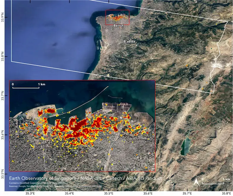
当地时间 2020 年 08 月 04 日,黎巴嫩首都贝鲁特的港口发生了一场大爆炸。之后,来自 NASA 和新加坡的两个团队利用雷达数据绘制了一幅描绘这场大爆炸影响程度的地图。这幅地图上用三种颜色的像素来描述地面设施遭受破坏的程度,分别是:暗红色、橙色和黄色。每个像素代表长和宽各为三十米的区域。
从这幅地图上可以看到,爆炸给贝鲁特造成了严重的破坏。绘制类似这样的地图可以帮助救援人员确定哪些区域的人们需要获得帮助。据悉,来自贝鲁特港口的这次爆炸导致了超过 150 人死亡并造成了至少数十亿美元的损失。
English Picture Description
August 4, 2020 local time, a big blast occurred in the port of Beirut. After that, two teams from NASA and Singapore made a map showing the extent of the blast by radar data. On this map, there are three colors which represent different extents of damage: dark red represents the most severe damage, orange represents moderate damage and yellow represents somewhat less damage. In addition, one color block is one pixel, and one pixel represents an area 30 meters long and 30 meters wide.
From this map we can see, the blast caused serious damage to Beirut. One of the functions of this map is to identify which people in these areas need help. I hope Beirut and the people who live there can return to normal as soon as possible.
References:
[1]. NASA Maps Beirut Blast Damage
https://www.nasa.gov/feature/jpl/nasa-maps-beirut-blast-damage
EOF
本站【科技图鉴】栏目每天早晨五点准时更新。
建议您收藏本站,不错过每一份精彩!
**本栏目还会不定时额外更新全球热点科技动态**