声明:
本文中的图片和英文原文均来自NASA,由导航狗对原文进行翻译,译文仅供参考。
原文链接:https://www.nasa.gov/image-feature/county-fire-lights-up-the-night
原文标题:County Fire Lights Up the Night
Manifesto:
The picture in this article and the English original text are all from NASA, DaoHangGou translated the original text and translated for reference only.
Original link: https://www.nasa.gov/image-feature/county-fire-lights-up-the-night
Original title: County Fire Lights Up the Night
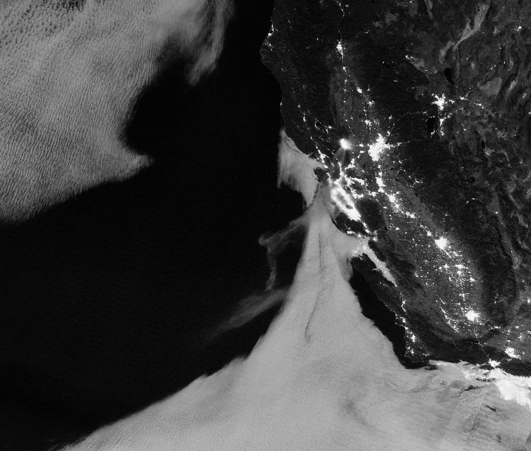
Light from the County Fire illuminated the night skies of Northern California when the Suomi NPP satellite acquired this image overnight on July 1, 2018. With plenty of light from a nearly full Moon, the smoke was even visible streaming southwest toward San Francisco Bay and the Pacific Ocean.
从美国极地气象卫星(Suomi NPP)于2018年07月01日晚上获得的这张图片可以看到,来自北加利福尼亚的山火照亮了整个夜空。在将近满月的充足光线下可以明显地看到烟雾朝向西南方向的旧金山湾和太平洋飘散。
The fire had started the day before and burned several thousands of acres near the rural community of Guinda, but it quadrupled in size overnight as strong winds fanned the flames in hot, dry weather. By the afternoon of July 3, the blaze—just 5 percent contained—had charred more than 70,000 acres (30,000 hectares) and forced hundreds of people to evacuate the area.
大火是前一天发生的,烧毁了Guinda附近几千英亩的农田,但是在炎热干燥的天气里,强风煽动着火焰使得山火的体积在一夜之间增大了四倍。截止到7月3日下午,仅有5%的火势被控制——有超过七万英亩(约合三万公顷)的土地被烧毁,数百人被迫撤离该地区。
This nighttime image was acquired with the “day night band” of the Visible Infrared Imaging Radiometer Suite (VIIRS) on Suomi. VIIRS detects light in a range of wavelengths from green to near-infrared and uses filtering techniques to observe signals such as city lights, auroras, and wildfires.
这张夜间图像是由Suomi上的可见红外线成像辐射计套件(VIIRS)使用“昼夜波段”捕捉到的。VIIRS可以探测到从绿色光到近红外线之间的一系列波长的光线并使用滤波技术来观察城市灯光、极光和野火之类的信号。
More: NASA Earth Observatory++
Image Credit: NASA Earth Observatory images by Joshua Stevens, using Suomi NPP VIIRS data from NOAA’s National Centers for Environmental Information (NCEI). Story by Adam Voiland
Last Updated: July 6, 2018
Editor: Yvette Smith